
Aerial Mapping
& Processing
CORE FEATURES:
Aerial LiDAR and High-Resolution Imagery Mapping
In-House Data Processing and Quality Control
UAS and Manned Aircraft Acquisition Capabilities With In-House Pilots and Sensor Operators
Client-Centered Deliverables, ranging from strip-aligned LAS files to surface meshes, CAD layers, and custom outputs
Aligned to ground control and independently verified against randomly distributed check points
Explore more details about our mapping services below.
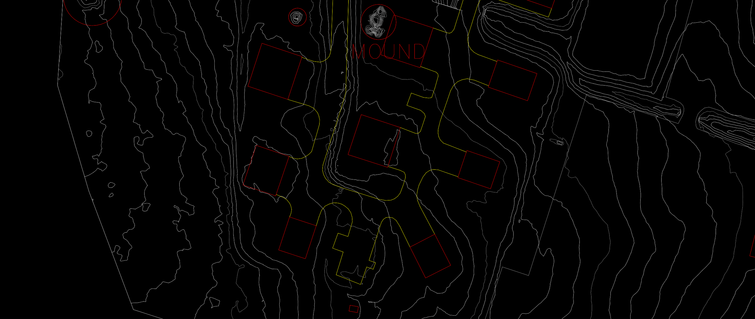
High-resolution 1-foot contour lines generated from aerial LiDAR data, with surveyed ground control points (GCPs) overlaid to validate vertical accuracy. This visualization highlights detailed terrain features, elevation changes, and site grading characteristics across the project area—supporting engineering, drainage, and design analysis.
-
LiDAR (Light Detection and Ranging) integrated with aerial platforms enables efficient collection of detailed three-dimensional data across a wide range of terrain and site conditions. Unlike traditional imagery, LiDAR is capable of capturing surface detail even through vegetation by recording multiple laser returns, allowing ground features to be identified beneath tree canopy and brush.
The resulting point cloud is processed and classified to distinguish ground, vegetation, structures, and other features. Ground points are isolated and used to generate accurate terrain products such as contours, surface meshes, and digital elevation models (DEMs), which integrate seamlessly with CAD, GIS, and engineering workflows.
Aerial LiDAR allows for rapid coverage of large or difficult-to-access areas, improving efficiency compared to conventional field-only methods. This approach is well suited for construction, land development, and infrastructure projects, and is commonly used to support engineering and surveying firms by providing consistent, well-structured surface data for downstream design, analysis, and validation workflows. -
High-resolution aerial imagery provides a clear, accurate visual record of sites and structures, captured efficiently by drone. These map-accurate imagery products offer a consistent view of the project area, making them easy to interpret and reliable for ongoing use.
Imagery is often collected alongside LiDAR, allowing visual context and surface data to align seamlessly. This enables imagery to be overlaid with planimetrics, CAD linework, and other spatial information, helping teams better understand site conditions and design intent.
Orthomosaics and imagery products are well suited for site documentation, design reference, and progress tracking over time. Their clarity and consistency support better communication, remote review, and confident decision-making across construction, land development, and infrastructure projects.
-
In-house data processing is a core part of our workflow and a key reason we’re able to maintain consistency, quality, and control across every deliverable. All LiDAR and imagery datasets are processed internally using robust, high-performance computing systems designed to handle large volumes of geospatial data efficiently and reliably.
By keeping processing local and in-house, we maintain direct oversight of data handling, classification, quality control, and final outputs. This approach supports secure data management, predictable turnaround times, and the ability to tailor processing parameters to the specific needs of each project.
We do not outsource data processing. Keeping this work internal allows us to stand behind our deliverables with confidence, ensure data integrity from acquisition through final output, and provide clients with consistent, dependable results they can trust.
-
Ground control provides a reliable reference that allows aerial data to align with real-world site conditions. Depending on project requirements, datasets are tied into existing ground control, control provided by a licensed surveyor, or control established internally, ensuring compatibility with established coordinate systems and downstream workflows.
To support confidence in the results, datasets are independently evaluated using check points that are not used to adjust or influence the data. This approach provides an objective assessment of performance, reflecting how LiDAR or imagery data compares to ground-based reference positions as collected.
Each project includes a clear accuracy report summarizing control alignment, check point results, and observed differences. This transparent process helps clients understand data quality and supports reliable use across engineering, surveying support, and design applications.

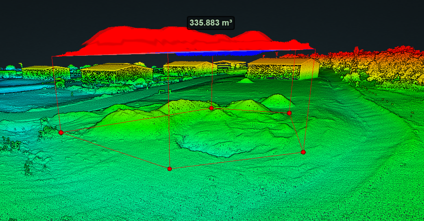
LiDAR-derived volumetric analysis showing precise cut-and-fill measurements calculated from a high-density point cloud. This visualization quantifies material volumes within a defined boundary, supporting earthwork planning, progress tracking, and verification with clear, defensible results.
This orthomosaic is a composite of hundreds of high-resolution aerial images, accurately stitched together using photogrammetry software. Delivered in GeoTIFF format, it supports precise zoom and can be easily overlaid with planimetrics, CAD data, and other geospatial layers—providing a reliable base for surveying, analysis, and design workflows.